Kakadu National Park

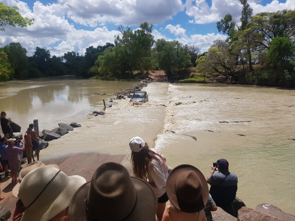
If you want to see a terrifying number of crocodiles lurking at a barramundi buffet, you need to see Cahill’s crossing at high tide! This is a water crossing for cars which crosses over the East Alligator River. It allows vehicles to go into Arnhem land. Cahill’s Crossing is located in Kakadu National Park in the Northern Territory of Australia. Before heading to this remote location, check the tide times to ensure you will arrive there just before high tide. You will be able to see the water change direction on the river, vehicles doing the water crossing despite the water being at a scarily high level, birds of prey swooping down for fish, large fish leaping out of the water and of course, lots of crocs!

As the water changes direction, fish are swept towards the crowd of waiting crocodiles. On the day we were there, there were about 30 crocodiles in the small stretch of river. Many of these managed to snare a large fish to eat. To be able to watch a large croc, maneuver a fish in its mouth to orient it for easier swallowing is a real privilege. There is a lookout over Cahill’s crossing that allow visitors to view the natural spectacle! It gets quite crowded and there were a number of people including children and fishermen down on the road by the water’s edge. Considering that crocodiles can both move and jump with deadly accuracy and speed, this seems extremely foolish.

A 4WD crossing the notorious Cahill’s Crossing, close to high tide. Those dark shapes in the water are not logs but waiting saltwater crocodiles!

When visiting Cahill’s Crossing, it is worth doing the walk from the crossing to Merl Campground. There are so many interesting rock formations to see on this walk.

Walking trail between Cahill’s Crossing and Merl Campground – note the little white egg shaped termite mounds!
Walking Trail between Cahill’s Crossing and Merl Campground – lots of interesting rock formations.

When visiting Kakadu National Park, doing the Yellow Water Cruise is essential. There is a so much animal and bird life that live on or close to the water. There is a cruise both at sunrise and sunset. Both are excellent. This time, we did the sunset cruise. The start of this cruise is at 4:30pm and it is searingly hot. Bring cool water and a hat and be prepared to be very hot!

During the cruise, we saw a lot of crocodiles, including a very large male croc, called Boofhead. We also witnessed a large herd of feral buffalo damaging the soft riverbank. They are both dangerous to humans in the park as well as extremely destructive to the park ecosystem. They were not easy to photograph as they stayed back from the river bank. Culling these feral buffaloes is not an easy task as the large carcasses will need to be disposed off. There are actually a lot of feral animals in Kakadu National Park. These pigs, horses, buffalo, etc are not native and alter the ecosystem by living there. There may even be some feral chickens in the park as I awoke in the morning by the crowing of a rooster!

There were birds aplenty to see during the Yellow Water Cruise. We saw elegant, white, egrets, Nankeen Night Herons hunting at the waters edge, Australasian Darters and Whistling Kites. There were large groups of Plumed Whistling Ducks squawking noisily at each other. The most memorable is the stunning tiny Azure Kingfisher darting from a riverbank tree to the water’s surface to hunt. The kingfisher is a deep blue and orange colour and it was so tiny and fast!

As the light changed and the searing heat eased, the tour guide ensured that we got to experience the sunset at a magical floodplain location. Those with expensive camera lenses could take lowlight sunset photos with a saltwater crocodile, native Jabiru bird and gorgeous sunset in the frame!

An Egret – Picture taken at the departure point of the Yellow River Cruise at Kakadu National Park
Boofhead, large male crocodile on the Yellow River Cruise
Yellow Water Cruise – sunset
Sunset on the Yellow Water Cruise
Nourlangie Lookout – Kakadu National Park – Australia is a vast country!
Nourlangie Lookout Walk

Porcupine Gorge National Park

A 45 minute drive, 65km north-east from Hughenden is the enchanting Porcupine Gorge National Park. Overnight camping available at Pyramid Campground. An easily accessible lookout provides a view from the top of the gorge but the hike down to the bottom of the gorge is worth doing. The landscape at the bottom is varied and geologically interesting. Cool off with a swim at the waterhole at the bottom or just relax. Then walk around the bottom of the gorge to look at the bizarre rock formations and the many colours in the rock.

Porcupine Gorge National Park
Porcupine Gorge
Porcupine Gorge National Park
Porcupine Gorge National Park – weird dimples in the rock with rock(s) within! Bizarre!

When passing through Hughenden, either to or from Porcupine Gorge, stop for a break at the historic Coolabah tree. This tree is part of the Burke and Wills story. These explorers were the first to traverse from the bottom of Australia to the top but died trying to head south for home. This tree was “blazed” i.e. marked by a couple of the rescue expeditions sent to find Burke and Wills. Their deaths were not in vain because the detailed notes Wills took along the journey which contributed to an understanding of what grazing land was available and assisted in opening up the country.

Historic Coolabah Tree

Discovering Marine Dinosaurs in the Flat Plains of Richmond, Queensland

Around 100 to 115 million years ago, current day outback Queenland, was dominated by a vast inland sea teeming with life. It seems quite improbable when looking at the sparse, dusty landscape in the area today. In Richmond, a tiny town of only 650 residents, there is a fabulous museum called Kronosaurus Korner. Despite being only a small town museum, most of the fossils are world class! Upon entering the museum, you are introduced to the world as it was 100 million years ago with an animated video showing the strange and wonderful creatures that lived in the water at the time. This video really helped contextualise the fossil displays and brought these amazing animals to life!

Road from Julia Creek to Richmond – very flat and sparse landscape now. Millions of years ago, this was a vast inland sea teeming with life resulting in the amazing marine fossils being found around Richmond.
Replica of a Kronosaurus at Kronosaurus Korner – a carnivorous, marine reptile, 9 – 11m in length that used to live in shallow inland seas.
Plesiosaur Skeleton – Look at the completeness of this skeleton and all those bones in the flippers! Amazing! What a stunningly preserved specimen housed in a small town museum!
Inside Kronosaurus Korner
Public bins in Richmond – this small town has an amazing history with fossils and dinosaurs. Love how even the bins carry on the theme!

Another marvelous aspect of this museum is that they allow ordinary people to purchase permits, at only $5, to dig for fossils at a couple of nearby sites. It is easy to assume that this is a tourism gimmick until you peruse the museum and see that a number of the most complete and interesting fossils have come in recent years from the free dig site and were found by ordinary people and tourists having a go!

The highlight of Richmond, Queensland is undoubtedly, Kronosaurus Korner. Despite that, do not leave without an easy stroll around the artifical Lake Fred Tritton. The path around the lake is well lit at night and wheelchair accessible. If you circumnavigate the lake clockwise, you will come across small brass plaques set into the walking path detailing the history of Richmond in chronological order. A lovely touch for visitors and a beautiful example of Richmond community pride. The lake is also stocked with fish for recreational fishing.

Lake Fred Tritton, Richmond

Mount Isa and Cloncurry

The commercial and population hub in outback, north Queensland is Mount Isa. The heart of this town is the Mount Isa Mines which mines for copper, lead, zinc and silver.

The town of Mount Isa is dominated by the imposing smoke stacks a short distance away in the mineral processing site now run by Glencore. There are three stacks, the largest of which is for the lead smelter. It was increased to it’s present tremendous height (270 m) in response to concerns about lead pollution of the town. This town is not unlike Karratha or Gladstone. Industry forms the beating heart of the town, it’s not traditionally pretty but plenty of people live and work here.

View from Mount Isa Lookout – note how close the mine is from the town centre
Mount Isa Mines

Around the back of the mines is a pretty, tidy and green suburban area. It seems more well off that other areas of Mount Isa. (Was that a gardener we spied as we cruised around for our quick tour?) In this area, there is also a heritage listed building called Casa Grande. This home was built in 1949 for the general manager of the mine. At the time, this was the largest house in outback Queensland and reflects a period when the mine finally became profitable after years of struggle which includes the depression and World War 2 years. The pretty suburb around Casa Grande is where the current managers and executives of the Mount Isa Mines have their homes.

Encourage those of you who are interested to read the Wikipedia article on the story of the Mount Isa Mine and the very significant adversities that were overcome as it developed into the very profitable and extensive operation it is today. Included, are some great stories of the world-class innovations that the miners pioneered at the plant. These innovations have since been employed elsewhere in the world under license.

Casa Grande

Driving 17km north of Mount Isa, will bring you to Lake Moondarra. This serene, artificial lake was made to provide water for the town and the mine. It has recreational areas on it’s banks and is used by locals for canoeing, boating, fishing, BBQs and picnics.

Lake Moondarra

Loitering at the recreational areas on the banks of the lakes are a number of peacocks. These birds are clearly used to being fed as they will approach any soft hearted candidates with enthusiasm and hope!

Peacocks at Lake Moondarra

The annual highlight in Mount Isa is the Mount Isa Rodeo. This is the biggest rodeo event in the southern hemisphere and is a well run and highly entertaining few days. Surprisingly, the music being played by the resident DJ was a real highlight and was sufficiently up-beat and intense to add to the frenetic performances from the competitors. Thankfully, country music was kept to a minimum.

The rodeo is also a great opportunity for people-watching country style with ‘fashions on the field’ consisting of cowboy hats and jeans plus well heeled boots.

Mount Isa Rodeo 2021
Mount Isa Rodeo Grounds
Chutes at Mount Isa Rodeo – this is where the riders get onto the bulls or broncs.
Bull riding at Mount Isa Rodeo – the protection crew/safety athletes/rodeo clowns in the blue and orange uniforms did an amazing job distracting the bull, thereby keeping the bull riders safe as possible from the bulls. They had to be fully aware because the bull could charge and gore them at any time!
8 seconds on a saddled bucking bronc!

The various bucking animals are induced to perform so spectacularly by the use of a so-called ‘flank strap’. This drives them crazy and induces the crazy twisting and jumping motion. The rodeo guide explained that the flank strap is not actually in contact with the beast’s genitals as happened in the past or perhaps still goes on with less scrupulous operators. It was remarkable how the animal calmed in a matter of moments once the flank strap was removed.

The bare-back bronc event consists of the same process, but with the absence of a saddle, it makes for wild ride indeed. The unfortunate rider makes a convincing impersonation of a rag doll as the horse tries to remove him from it’s back. Suspicions are that the competitors brains will be adversely affected from all the impact.

Mount Isa Rodeo – riders in white remove the flank strap from the bronc and escort it off the main arena
Victory Lap for the placeholders for an event at the Mount Isa Rodeo. Winners receive a ribbon, a belt buckle and prize money. No mention if chiropractic consultation was also included.

Sideshow Alley at Mount Isa Rodeo

Sideshow alley wasn’t drawing many customers when we were there, COVID no doubt wasn’t helping.

Chinaman Creek Dam, near Cloncurry
Burke and Wills Monument

Burke and his faithful Wills are a celebrated tragedy and perhaps an example of the courageous amateur biting off more than they can chew. This duo were the first to travel from Melbourne, in the bottom of Australia to the Gulf of Carpentaria at the top but died not long after starting their journey back down. Nevertheless, hats off to these and others who opened up this vast, brown land. Whilst ruminating on the experience these men and their unfortunate followers went through as they suffered and died, we couldn’t help but wonder if the whole trip would have been easier with some participation from the Aborigines (even if not from the local area). It’s also not clear why the didn’t send through another party by ship to meet them at the Gulf of Carpentaria.

Mount Isa to Cloncurry – the drive takes you past spectacular reddish, rocky hills.

Driving from Cairns to the Gulf of Carpentaria

From lush tropical rainforests to the sparse, desolate, dusty outback, this journey took us through very contrasting landscapes. The buzzy tourist filled city of Cairns to the small fishing town of Karumba, and a number of interesting stops in between.

Cairns is one of the best cities in Australia in the cold months of the year (in my opinion). The weather in July is perfection! The roads around Cairns is flat with plenty of infrastructure to make cycling very safe. There are free Zumba classes around town paid for by the Cairns council. The lagoon(free beachside public swimming pool) is gorgeous and there are lots of restaurants reflecting the multicultural communities that call Cairns home. Around Cairns is the Great Barrier Reef and a whole bunch of waterfalls and other verdant natural sights.

Not far outside of Cairns is the Atherton tableland regions. This is considered tropical dairy country. The countryside is fertile and lush. There are plenty of waterfalls, waterholes and walks to visit. Only two waterfalls are mentioned here but there are plenty more! We camped beside Lake Tinnaroo and beside a pretty creek out the back of the Tall Timbers Caravan Park near Ravenshoe. Ravenshoe is the highest town in Queensland so the overnight temperature was much cooler than in Cairns!

Lake Tinnaroo, near Yungaburra. This picture only shows a tiny fraction of the lake.
Creek behind Tall Timbers Caravan Park – the unpowered sites are amongst the trees and you can park right by the creek!
Dinner Falls in Mount Hypipamee National Park
Dinner Falls
Windy Hill Wind Farm near Ravenshoe, Queensland, commissioned in 2000
Mungalli Falls
Mungalli Falls

From the Atherton tablelands, we headed to the Undara Volcanic National Park. A “must-do” on the way there is to stop at a town called Innot Hot Springs. You can either experience the hot springs at the natural creek outside the caravan park or you can pay $10 per person to enjoy the hot mineral waters inside the park where it is directed into 6 different temperature controlled pools. We found the natural creek to be very shallow, muddy and mossy. The water can be scalding in areas so be careful! People get their shovel and make pools which mix some hot and cooler water to get a place to soak at the right temperature.

Innot Hot Springs – hot mineral water in Nettle Creek.

We headed inside the caravan park and found a good facility with pools ranging in temperatures up to 45C. You can soak outdoors or indoors and it was incredibly relaxing. It’s also a good place for a chat with other travelers.

Feeling relaxed, we continued our journey to the Undara Experience Caravan Park. The scenery is now much more dusty and sandy. The lava tube tour at Undara Experience was interesting and there are some underwhelming walks nearby to do.

Undara Volcanic Lava Tubes
Undara Lava Tubes
Dining Facilities at Undara Experience – they use railway carriages here and for guest accomodation.
Landscape around Undara Experience Caravan Park
Sunset over Undara Experience Caravan Park

Driving to Croydon from Undara, feels like we are truly in the outback. There is not even a sniff of mobile signal and the major highway often annoying reduces to a single lane.

Single lane highway to Croydon – very annoying when there is a car coming the other way flinging up dust and stones onto our vehicle!
The road to Croydon alternates between double lane and single lane sealed road. The lush rainforests of Cairns are well behind us!

Croydon is an interesting tiny town of 250 with an interesting gold rush history. Gold was discovered in the later 1800s causing the town to boom as people rushed to mine the gold. There is an informative video at the information centre which details the history. Amongst the people who rushed to find wealth were Chinese people. Due to racism, the Chinese were unable to mine for gold till the lease had been mined for 3 years. Instead, many of the Chinese people started market gardens. Nurturing a profitable market garden in this inhospitable climate which is either desperately bone dry or much too wet is no easy feat. The Chinese supplied the town with their fresh fruit and vegetables but it was due to much hard work hand carrying water and hand watering their plants with just the most meagre ration of water required to survive.

Old Gold Mining Equipment, Croydon

Onwards to Karumba, the town on the Gulf of Carpentaria. This is a sleepy, fishing obsessed town. There were a lot of locusts about when we visited so correspondingly, there were a number of birds enjoying a feast! There is absolutely no Optus network signal in Karumba but in Normanton, an hour inland, there is a mobile tower and super strong Optus mobile signal!

Gulf of Carpentaria, Karumba – stunning blue water but as usual, a croc warning sign!

Don’t forget to visit Krys the 8.6m crocodile replica in Normanton. This is supposed to be a replica of the largest crocodile shot in the area by a Polish lady named Krys in 1957. Unfortunately, the measurement was not verified. The largest officially verified crocodile (as per the Guinness Book of Records) is 6.17m.

Krys, a replica of an 8.6m crocodile shot in 1957.
Norman River

The Norman River runs past the town of Normanton. There is a double lane vehicle bridge that spans the river. There is also a separate bridge specifically for fishing!! It comes with many useful things for an enjoyable fishing day like rod holders, shade structures, BBQs, picnic tables and running water!! What an amazing piece of infrastructure for this tiny town of 1200 people!

Visiting the Daintree Region of Far North Queensland

The lush rainforest region of the Daintree is very beautiful. Catch the ferry across the Daintree River and tour this charming region around Cape Tribulation. This area is accessible by 2WD until just north of Cape Tribulation. Despite this, there is plenty to see with a 2WD and it is worth taking a few days or a long day trip to check it out. The ferry is very quick and runs frequently during daylight hours. This whole area is beautiful enough to be a national park but it also includes commercial businesses like accommodation, stores, restaurants and caravan parks. There area also private residences, schools and farmland e.g. tropical fruit orchards.

Prior to our visit to Cape Tribulation, we were warned online about the lack of mobile data in the region. This proved not to be true. Whilst patchy in some parts, there was plenty of reliable (Optus) mobile data in the region. We had no issues whilst staying at Cape Tribulation Camping with mobile data. The highlight of this caravan park was the private walking trail from the back of our campsite to Myall Beach. From there, it was only a short walk up the beach to reach the Dubuji Boardwalk.

Myall Beach
Daintree
Daintree – amazing flowering tree trunk!
Crocodile Warning Sign
Myall Beach
Mount Alexandra Lookout
Daddy Cassowary and Baby – why did the cassowary cross the road? We don’t know but we were thrilled to see these elusive big birds!

A must visit location in the area is the Daintree Ice Cream Company. They make ice cream from the locally grown tropical fruits. We had a yummy taster of 4 flavours – wattleseed, black sapote, mango and coconut for $7.50. The best part of the visit however is the self guided walking tour you can do around their property to view about 25 different fruiting trees and plants. It’s particularly fascinating because these fruits are not the usual supermarket offerings!

Ripening Shed – top is Black Sapote or chocolate pudding fruit. It tastes a bit like chocolate pudding! In the middle is Yellow Sapote. This is supposed to taste like boiled egg yolk. On the bottom is Soursop which has a lemony flavour.
Soursop
Banana Fruit and Flower

Mossman Gorge is a must visit if you are in the vicinity. It’s the premier attraction of the region as evidenced by the large carpark. There is a large building with a souvenir shop, cafe and shuttle buses. All this infrastructure is located about 3kms from the start of the Mossman Gorge trails. All visitors are strongly encouraged to pay for tickets and catch the shuttle bus. We chose to walk the 3km instead. It’s a straightforward and quite lovely walk along the road and an easy way to save some money. There are several well trodden trails in the Mossman Gorge area as well as a few safe swimming areas. Be warned however that the water temperature is almost uncomfortably cold for swimming despite the warm humidity of the day. The whole area is magical in it’s beauty as you will see in these photos.

Mossman Gorge
Mossman Gorge
Mossman Gorge
Mossman Gorge
Mossman Gorge – lots of strangler figs in this part of the Australia. They can be truly spectacular.
Mossman Gorge – See how the strangler fig has entirely strangled the original plant. The original tree is dead but the strangler fig is thriving. (Feels like a lesson for life! Don’t be that tree or the strangler!)
Mossman Gorge – check out this crazy perfectly horizontal branch which seems to originate from two separate trees! Amazing and baffling!
Mossman Gorge
Mossman Gorge
Mossman Gorge – strangler fig making a beautiful pattern
Mossman Gorge
Mossman Gorge – sugar cane plantation in flower. Walking towards the Mossman Gorge trail heads

Close to the town of Mossman is a tiny one street, waterfront town of Newell Beach, population 336. It’s a relaxing location with a delightful beach.

Newell Beach

Cooktown – 3 night self drive itinerary

Cooktown is the northern-most town that is accessible by 2WD vehicles on the east coast of Australia. Cooktown is about 4 hours north of Cairns via in the inland route. If you have a 4WD, you can also access Cooktown via the coastal route via Bloomfield. There is plenty in and around Cooktown to pleasantly occupy a visitor for a 3 night stay. This is our itinerary!

Day 1 – Drive up to Cooktown and Orient Yourself

On the drive up to Cooktown via the inland route via Mulligan Highway, there are a couple of lookouts worth stopping at to stretch your legs. Stop at Bob’s Lookout near Desailly and at the Black Mountain National Park lookout.

Black Mountain (Kalkajaka) National Park

When you get to Cooktown, orient yourself by heading up to the Grassy Hill Lookout. The 360 degree view is spectacular!!

Grassy Hill Lookout
Grassy Hill Lookout
View of Cooktown from Grassy Hill Lookout
Lighthouse, Grassy Hill Lookout

Day 2 – Visit Sights South of Cooktown

Start the day with a visit to Keating’s Lagoon Conservation Park which is only 10 minutes south of Cooktown. It’s a very pretty area and has a structure for birdwatching.

Keating’s Lagoon Conservation Park

After that, head further south to the Home Rule Rainforest Lodge and Camping. There are clear signage and trail markers from behind this property for walking to Home Rule Falls. The hike to Home Rule Falls is a bit strenuous and tricky in parts but the reward at the end is definitely worth it. The falls are magical and to have time at such a spectacular sight without any other visitors is really special. The pictures does not do it justice at all!

Track to Home Rule Falls
Home Rule Falls
Home Rule Falls
Home Rule Falls

Drive further south past Bloomfield to the dry (alcohol free) town of Wujal Wujal. The jewel of this town is the magnificent Wujal Wujal Falls. There are supposed to be areas in this town where crocodiles can be spotted sunning themselves on the riverbank at low tide but we were unable to spot any!

Wujal Wujal Falls

Head north home via the famous Lion’s Den Pub. This is a classic outback pub reminiscent of the Daly Waters pub in the Northern Territory.

Lions Den Hotel -Pub and Campground

Day 3 – Visit Sights North and around Cooktown

Start the day by driving about 30 minutes north to the Endeavour Falls Tourist Park. The delightful Endeavour Falls is a short walk from behind this park.

Endeavour Falls

Only 10 minutes north from Endeavour Falls is Isabella Falls. This location is a safe swimming hole (i.e. no crocodiles!) It’s a good spot for a refreshing albeit chilly dip!

Isabella Falls
Isabella Falls

Make your way back to Cooktown to spend sometime at the Cooktown Museum. Stroll through the small but charming Cooktown Botanic Gardens. Don’t forget to drive through the botanic gardens to see Finch Bay. A splendid looking beach but as with most water bodies in this region, swimming is prohibited due to the risk of crocodiles.

Finch Bay, Cooktown
Finch Bay, Cooktown
Finch Bay, Cooktown
Finch Bay, Cooktown
Finch Bay, Cooktown

Whilst in Cooktown, the markets are worth a quick walk if you are there on a Saturday morning. It’s held down by the waterfront. Even if the markets are not running, the waterfront area is worth a stroll as there are many public artworks documenting the history of the region. A local’s secret in Cooktown is an unassuming, low key cafe on the waterfront next to the laundromat. Head to the Riverside Cafe in the morning to pick up a reasonably priced French patisserie style sweet treat!

Riverside Cafe, Cooktown. An impressive selection for Cooktown with a population of only about 2600 people. A talented French pastry chef must call this town home!

An interesting (and perhaps worrying) thing to note is that when we visited, we noticed a lot of “for sale” signs. Many businesses, plots of land and residential properties had “for sale” signs displayed. It is not clear why. Potentially, these may be a profitable purchase if the Bloomfield track is made accessible for 2WD allowing greater volumes of visitors (and attracting more residents) up to Cooktown.

The Unexpectedly Awesome Granite Gorge Nature Park

Granite Gorge Nature Park is a bit of a hidden gem. Its only 16 minutes outside of Mareeba or 70 minutes from Cairns in Northern Queensland. The landscape and vegetation around here is much drier than the lush wet tropics of Cairns. The caravan park is lovely but the highlights of this park are the gorge walk, the tiny, cute Mareeba Rock Wallabies and the huge number of animals at the park.

Visitors at this park are allowed to feed the wallabies with pellets purchased from reception. We didn’t feed them but as they are so used to being fed, they are quite tame and will approach closely to any humans with expectant looks on their little faces. We therefore managed to get many good photos.

Mareeba Rock Wallaby

There are huge number of animals around the park. It would be great for kids but also fascinating for us adults! There are noisy geese and fluffy, fancy chickens wandering about loose, a pig, ponies, lizards, water dragons, guinea pigs, snakes and lots of colourful birds. The lady at reception offered us several times the opportunity to hold these animals if we wanted. We also chanced upon the feeding of the snakes with mice and chicks. These were dead before feeding the snake but warmed to tempt the snakes to eat!

Snake being fed with a dead, warmed, young chicken
Pig

The walking tracks that go from behind the reception building are a little tricky in places but worth doing for the spectacular and unusual boulder filled scenery. The shorter, yellow marked walk is easier and takes you to a pretty water body for swimming. The much harder, red marked walk involves a fair amount of clambering over rocks but you can see dinosaur footprints and a pretty gorge lookout!

Granite Gorge Walk
Granite Gorge Walk
Granite Gorge Walk
Granite Gorge Walk
Granite Gorge Walk
Granite Gorge Walk
Granite Gorge Walk – dinosaur footprints!!!
Speckled rock but the speckles on the rock are really fine webs spun by a spider or some other insect
Granite Gorge Walk
Granite Gorge Walk
Granite Gorge Walk – swimming hole
Granite Gorge Lookout
Granite Gorge Walk

If you are in the vicinity of Mareeba, Skybury Coffee is worth a visit. It has a cafe on a high balcony overlooking the pretty vista and free tastings of coffee, papayas and papaya jam at the shop. The most fascinating part of this operation is how they double crop papaya trees and coffee trees. There is a small movie theater and signage with information about this method of farming.

The papaya trees are planted and these produce fruit for sale between 8 months and 2.5 years. When the tree gets to a certain height, young coffee trees are planted under the papaya trees. The papaya trees protect and shade the young coffee trees while they mature to a productive age. Coffee trees planted under papaya trees mature to productivity much faster than those planted alone. Once the coffee trees are ready for harvest, the papaya trees will have passed their useful age and have been removed. This method increases the yield from the same bit of land with only a marginal increase in water and fertilizers. Fascinating stuff!!